| at: |
Sumter National Forest - Enoree District |
Data from USFS GIS
 show on map
 animate
Trail users:


Elevation Profile
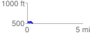
 0.536745 mi
 36.31 ft
 60.04 ft
 -23.73 ft
 2.12 %
GPX Downloads: Track Route
![]()
| at: |
Sumter National Forest - Enoree District |
show on map
animate
0.536745 mi
36.31 ft
60.04 ft
-23.73 ft
2.12 %