| at: |
Sumter National Forest - Enoree District |
Data from USFS GIS
 show on map
 animate
Trail users:


Elevation Profile
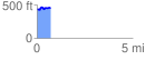
 0.709092 mi
 76.31 ft
 61.93 ft
 14.38 ft
 2.04 %
GPX Downloads: Track Route
![]()
| at: |
Sumter National Forest - Enoree District |
show on map
animate
0.709092 mi
76.31 ft
61.93 ft
14.38 ft
2.04 %