| at: |
Sumter National Forest - Enoree District |
Data from USFS GIS
 show on map
 animate
Trail users:


Elevation Profile
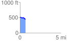
 0.691601 mi
 17.06 ft
 98.37 ft
 -81.31 ft
 2.69 %
GPX Downloads: Track Route
![]()
| at: |
Sumter National Forest - Enoree District |
show on map
animate
0.691601 mi
17.06 ft
98.37 ft
-81.31 ft
2.69 %