|
| at: |
Sumter National Forest - Enoree District |
Data from USFS GIS
 show on map
 animate
Trail users:


Elevation Profile
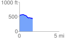
 1.682408 mi
 40.35 ft
 151.77 ft
 -111.42 ft
 1.71 %
GPX Downloads: Track Route
![]()
|
| at: |
Sumter National Forest - Enoree District |
show on map
animate
1.682408 mi
40.35 ft
151.77 ft
-111.42 ft
1.71 %