| at: |
Sumter National Forest - Enoree District |
Data from USFS GIS
 show on map
 animate
Trail users:


Elevation Profile
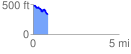
 0.921219 mi
 67.55 ft
 199.40 ft
 -131.85 ft
 4.10 %
GPX Downloads: Track Route
![]()
| at: |
Sumter National Forest - Enoree District |
show on map
animate
0.921219 mi
67.55 ft
199.40 ft
-131.85 ft
4.10 %