|
| at: |
Sumter National Forest - Enoree District |
Data from USFS GIS
 show on map
 animate
Trail users:


Elevation Profile
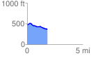
 1.852510 mi
 52.36 ft
 160.34 ft
 -107.98 ft
 1.64 %
GPX Downloads: Track Route
![]()
|
| at: |
Sumter National Forest - Enoree District |
show on map
animate
1.852510 mi
52.36 ft
160.34 ft
-107.98 ft
1.64 %