| at: |
Sumter National Forest - Enoree District Enoree OHV Trail |
Data from USFS GIS
 show on map
 animate
Trail users:


Elevation Profile
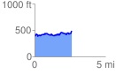
 2.634457 mi
 540.19 ft
 451.53 ft
 88.66 ft
 3.88 %
GPX Downloads: Track Route
![]()
| at: |
Sumter National Forest - Enoree District Enoree OHV Trail |
show on map
animate
2.634457 mi
540.19 ft
451.53 ft
88.66 ft
3.88 %