| at: |
Sumter National Forest - Enoree District Woods Ferry Recreation Area |
Data from USFS GIS
 show on map
 animate
Trail users:


Elevation Profile
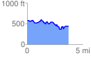
 3.941032 mi
 459.85 ft
 603.65 ft
 -143.80 ft
 2.90 %
GPX Downloads: Track Route
![]()
| at: |
Sumter National Forest - Enoree District Woods Ferry Recreation Area |
show on map
animate
3.941032 mi
459.85 ft
603.65 ft
-143.80 ft
2.90 %