|
| at: |
Francis Marion National Forest |
Data from USFS GIS
 show on map
 animate
Trail users:


Elevation Profile
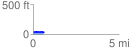
 0.638151 mi
 37.02 ft
 41.18 ft
 -4.16 ft
 1.22 %
GPX Downloads: Track Route
![]()
|
| at: |
Francis Marion National Forest |
show on map
animate
0.638151 mi
37.02 ft
41.18 ft
-4.16 ft
1.22 %