|
| at: |
Francis Marion National Forest |
Data from USFS GIS
 show on map
 animate
Trail users:


Elevation Profile
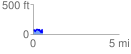
 0.556667 mi
 98.94 ft
 139.70 ft
 -40.76 ft
 4.75 %
GPX Downloads: Track Route
![]()
|
| at: |
Francis Marion National Forest |
show on map
animate
0.556667 mi
98.94 ft
139.70 ft
-40.76 ft
4.75 %