|
| at: |
Francis Marion National Forest |
Data from USFS GIS
 show on map
 animate
Trail users:


Elevation Profile
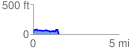
 1.514483 mi
 139.21 ft
 171.14 ft
 -31.94 ft
 2.14 %
GPX Downloads: Track Route
![]()
|
| at: |
Francis Marion National Forest |
show on map
animate
1.514483 mi
139.21 ft
171.14 ft
-31.94 ft
2.14 %