|
| at: |
Francis Marion National Forest |
Data from USFS GIS
 show on map
 animate
Trail users:


Elevation Profile
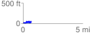
 0.719310 mi
 143.67 ft
 131.73 ft
 11.94 ft
 3.78 %
GPX Downloads: Track Route
![]()
|
| at: |
Francis Marion National Forest |
show on map
animate
0.719310 mi
143.67 ft
131.73 ft
11.94 ft
3.78 %