|
| at: |
Francis Marion National Forest |
Data from USFS GIS
 show on map
 animate
Trail users:


Elevation Profile
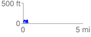
 0.431642 mi
 118.59 ft
 130.87 ft
 -12.28 ft
 5.74 %
GPX Downloads: Track Route
![]()
|
| at: |
Francis Marion National Forest |
show on map
animate
0.431642 mi
118.59 ft
130.87 ft
-12.28 ft
5.74 %