|
| at: |
Francis Marion National Forest |
Data from USFS GIS
 show on map
 animate
Trail users:


Elevation Profile
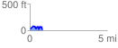
 0.814357 mi
 153.45 ft
 165.97 ft
 -12.52 ft
 3.86 %
GPX Downloads: Track Route
![]()
|
| at: |
Francis Marion National Forest |
show on map
animate
0.814357 mi
153.45 ft
165.97 ft
-12.52 ft
3.86 %