|
| at: |
Francis Marion National Forest |
Data from USFS GIS
 show on map
 animate
Trail users:


Elevation Profile
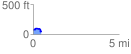
 0.460793 mi
 48.62 ft
 61.76 ft
 -13.14 ft
 2.54 %
GPX Downloads: Track Route
![]()
|
| at: |
Francis Marion National Forest |
show on map
animate
0.460793 mi
48.62 ft
61.76 ft
-13.14 ft
2.54 %