|
| at: |
Francis Marion National Forest |
Data from USFS GIS
 show on map
 animate
Trail users:


Elevation Profile
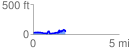
 1.900582 mi
 233.51 ft
 220.20 ft
 13.31 ft
 2.33 %
GPX Downloads: Track Route
![]()
|
| at: |
Francis Marion National Forest |
show on map
animate
1.900582 mi
233.51 ft
220.20 ft
13.31 ft
2.33 %