|
| at: |
Francis Marion National Forest |
Data from USFS GIS
 show on map
 animate
Trail users:


Elevation Profile
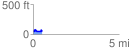
 0.536880 mi
 74.86 ft
 81.37 ft
 -6.52 ft
 2.87 %
GPX Downloads: Track Route
![]()
|
| at: |
Francis Marion National Forest |
show on map
animate
0.536880 mi
74.86 ft
81.37 ft
-6.52 ft
2.87 %