|
| at: |
Francis Marion National Forest |
Data from USFS GIS
 show on map
 animate
Trail users:


Elevation Profile
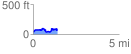
 1.417081 mi
 185.72 ft
 143.96 ft
 41.76 ft
 2.48 %
GPX Downloads: Track Route
![]()
|
| at: |
Francis Marion National Forest |
show on map
animate
1.417081 mi
185.72 ft
143.96 ft
41.76 ft
2.48 %