|
| at: |
Francis Marion National Forest |
Data from USFS GIS
 show on map
 animate
Trail users:


Elevation Profile
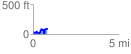
 0.866250 mi
 186.66 ft
 171.90 ft
 14.76 ft
 4.08 %
GPX Downloads: Track Route
![]()
|
| at: |
Francis Marion National Forest |
show on map
animate
0.866250 mi
186.66 ft
171.90 ft
14.76 ft
4.08 %