|
| at: |
Francis Marion National Forest |
Data from USFS GIS
 show on map
 animate
Trail users:


Elevation Profile
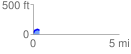
 0.367405 mi
 70.92 ft
 18.27 ft
 52.64 ft
 3.66 %
GPX Downloads: Track Route
![]()
|
| at: |
Francis Marion National Forest |
show on map
animate
0.367405 mi
70.92 ft
18.27 ft
52.64 ft
3.66 %