|
| at: |
Francis Marion National Forest |
Data from USFS GIS
 show on map
 animate
Trail users:


Elevation Profile
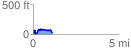
 1.124338 mi
 194.92 ft
 188.69 ft
 6.23 ft
 3.28 %
GPX Downloads: Track Route
![]()
|
| at: |
Francis Marion National Forest |
show on map
animate
1.124338 mi
194.92 ft
188.69 ft
6.23 ft
3.28 %