|
| at: |
Francis Marion National Forest |
Data from USFS GIS
 show on map
 animate
Trail users:


Elevation Profile
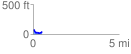
 0.509010 mi
 65.91 ft
 69.36 ft
 -3.45 ft
 2.58 %
GPX Downloads: Track Route
![]()
|
| at: |
Francis Marion National Forest |
show on map
animate
0.509010 mi
65.91 ft
69.36 ft
-3.45 ft
2.58 %