|
| at: |
Francis Marion National Forest |
Data from USFS GIS
 show on map
 animate
Trail users:


Elevation Profile
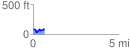
 0.658221 mi
 72.98 ft
 84.59 ft
 -11.61 ft
 2.43 %
GPX Downloads: Track Route
![]()
|
| at: |
Francis Marion National Forest |
show on map
animate
0.658221 mi
72.98 ft
84.59 ft
-11.61 ft
2.43 %