|
| at: |
Francis Marion National Forest |
Data from USFS GIS
 show on map
 animate
Trail users:


Elevation Profile
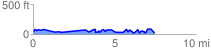
 7.478985 mi
 511.85 ft
 518.44 ft
 -6.59 ft
 1.31 %
GPX Downloads: Track Route
![]()
|
| at: |
Francis Marion National Forest |
show on map
animate
7.478985 mi
511.85 ft
518.44 ft
-6.59 ft
1.31 %