|
| at: |
Francis Marion National Forest |
Data from USFS GIS
 show on map
 animate
Trail users:


Elevation Profile
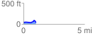
 1.014717 mi
 63.11 ft
 69.98 ft
 -6.86 ft
 1.31 %
GPX Downloads: Track Route
![]()
|
| at: |
Francis Marion National Forest |
show on map
animate
1.014717 mi
63.11 ft
69.98 ft
-6.86 ft
1.31 %