|
| at: |
Francis Marion National Forest |
Data from USFS GIS
 show on map
 animate
Trail users:


Elevation Profile
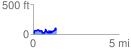
 1.360671 mi
 310.92 ft
 261.10 ft
 49.82 ft
 4.33 %
GPX Downloads: Track Route
![]()
|
| at: |
Francis Marion National Forest |
show on map
animate
1.360671 mi
310.92 ft
261.10 ft
49.82 ft
4.33 %