|
| at: |
Francis Marion National Forest |
Data from USFS GIS
 show on map
 animate
Trail users:


Elevation Profile
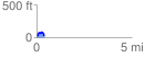
 0.434445 mi
 73.63 ft
 67.48 ft
 6.15 ft
 3.21 %
GPX Downloads: Track Route
![]()
|
| at: |
Francis Marion National Forest |
show on map
animate
0.434445 mi
73.63 ft
67.48 ft
6.15 ft
3.21 %