|
| at: |
Francis Marion National Forest |
Data from USFS GIS
 show on map
 animate
Trail users:


Elevation Profile
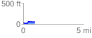
 0.957680 mi
 72.26 ft
 37.92 ft
 34.34 ft
 1.43 %
GPX Downloads: Track Route
![]()
|
| at: |
Francis Marion National Forest |
show on map
animate
0.957680 mi
72.26 ft
37.92 ft
34.34 ft
1.43 %