|
| at: |
Francis Marion National Forest |
Data from USFS GIS
 show on map
 animate
Trail users:


Elevation Profile
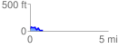
 0.810429 mi
 87.25 ft
 114.11 ft
 -26.86 ft
 2.67 %
GPX Downloads: Track Route
![]()
|
| at: |
Francis Marion National Forest |
show on map
animate
0.810429 mi
87.25 ft
114.11 ft
-26.86 ft
2.67 %