|
| at: |
Francis Marion National Forest |
Data from USFS GIS
 show on map
 animate
Trail users:


Elevation Profile
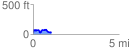
 1.058526 mi
 158.08 ft
 148.67 ft
 9.41 ft
 2.83 %
GPX Downloads: Track Route
![]()
|
| at: |
Francis Marion National Forest |
show on map
animate
1.058526 mi
158.08 ft
148.67 ft
9.41 ft
2.83 %