|
| at: |
Francis Marion National Forest |
Data from USFS GIS
 show on map
 animate
Trail users:


Elevation Profile
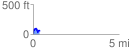
 0.363550 mi
 109.55 ft
 113.11 ft
 -3.56 ft
 5.89 %
GPX Downloads: Track Route
![]()
|
| at: |
Francis Marion National Forest |
show on map
animate
0.363550 mi
109.55 ft
113.11 ft
-3.56 ft
5.89 %