|
| at: |
Francis Marion National Forest |
Data from USFS GIS
 show on map
 animate
Trail users:


Elevation Profile
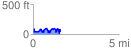
 1.615617 mi
 409.67 ft
 449.90 ft
 -40.23 ft
 5.27 %
GPX Downloads: Track Route
![]()
|
| at: |
Francis Marion National Forest |
show on map
animate
1.615617 mi
409.67 ft
449.90 ft
-40.23 ft
5.27 %