|
| at: |
Francis Marion National Forest |
Data from USFS GIS
 show on map
 animate
Trail users:


Elevation Profile
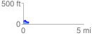
 0.492955 mi
 21.71 ft
 54.61 ft
 -32.90 ft
 2.10 %
GPX Downloads: Track Route
![]()
|
| at: |
Francis Marion National Forest |
show on map
animate
0.492955 mi
21.71 ft
54.61 ft
-32.90 ft
2.10 %