|
| at: |
Francis Marion National Forest |
Data from USFS GIS
 show on map
 animate
Trail users:


Elevation Profile
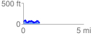
 1.369795 mi
 255.44 ft
 263.06 ft
 -7.62 ft
 3.64 %
GPX Downloads: Track Route
![]()
|
| at: |
Francis Marion National Forest |
show on map
animate
1.369795 mi
255.44 ft
263.06 ft
-7.62 ft
3.64 %