|
| at: |
Francis Marion National Forest |
Data from USFS GIS
 show on map
 animate
Trail users:


Elevation Profile
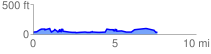
 7.664182 mi
 538.65 ft
 546.20 ft
 -7.54 ft
 1.35 %
GPX Downloads: Track Route
![]()
|
| at: |
Francis Marion National Forest |
show on map
animate
7.664182 mi
538.65 ft
546.20 ft
-7.54 ft
1.35 %