|
| at: |
Francis Marion National Forest |
Data from USFS GIS
 show on map
 animate
Trail users:


Elevation Profile
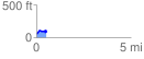
 0.534264 mi
 105.47 ft
 67.72 ft
 37.75 ft
 3.74 %
GPX Downloads: Track Route
![]()
|
| at: |
Francis Marion National Forest |
show on map
animate
0.534264 mi
105.47 ft
67.72 ft
37.75 ft
3.74 %