|
| at: |
Francis Marion National Forest |
Data from USFS GIS
 show on map
 animate
Trail users:


Elevation Profile
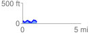
 1.219800 mi
 171.13 ft
 166.25 ft
 4.88 ft
 2.66 %
GPX Downloads: Track Route
![]()
|
| at: |
Francis Marion National Forest |
show on map
animate
1.219800 mi
171.13 ft
166.25 ft
4.88 ft
2.66 %