|
| at: |
Francis Marion National Forest |
Data from USFS GIS
 show on map
 animate
Trail users:


Elevation Profile
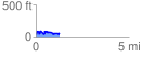
 1.250597 mi
 164.45 ft
 137.34 ft
 27.11 ft
 2.49 %
GPX Downloads: Track Route
![]()
|
| at: |
Francis Marion National Forest |
show on map
animate
1.250597 mi
164.45 ft
137.34 ft
27.11 ft
2.49 %