|
| at: |
Francis Marion National Forest |
Data from USFS GIS
 show on map
 animate
Trail users:


Elevation Profile
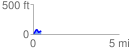
 0.462453 mi
 86.11 ft
 42.50 ft
 43.62 ft
 3.53 %
GPX Downloads: Track Route
![]()
|
| at: |
Francis Marion National Forest |
show on map
animate
0.462453 mi
86.11 ft
42.50 ft
43.62 ft
3.53 %