|
| at: |
Francis Marion National Forest |
Data from USFS GIS
 show on map
 animate
Trail users:


Elevation Profile
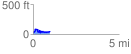
 0.967252 mi
 125.30 ft
 123.36 ft
 1.94 ft
 2.45 %
GPX Downloads: Track Route
![]()
|
| at: |
Francis Marion National Forest |
show on map
animate
0.967252 mi
125.30 ft
123.36 ft
1.94 ft
2.45 %