|
| at: |
Francis Marion National Forest |
Data from USFS GIS
 show on map
 animate
Trail users:


Elevation Profile
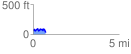
 0.721229 mi
 124.83 ft
 147.14 ft
 -22.31 ft
 3.86 %
GPX Downloads: Track Route
![]()
|
| at: |
Francis Marion National Forest |
show on map
animate
0.721229 mi
124.83 ft
147.14 ft
-22.31 ft
3.86 %