|
| at: |
Francis Marion National Forest |
Data from USFS GIS
 show on map
 animate
Trail users:


Elevation Profile
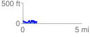
 1.240859 mi
 248.82 ft
 241.06 ft
 7.76 ft
 3.80 %
GPX Downloads: Track Route
![]()
|
| at: |
Francis Marion National Forest |
show on map
animate
1.240859 mi
248.82 ft
241.06 ft
7.76 ft
3.80 %