|
| at: |
Francis Marion National Forest |
Data from USFS GIS
 show on map
 animate
Trail users:


Elevation Profile
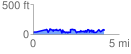
 4.135746 mi
 728.20 ft
 721.74 ft
 6.46 ft
 3.33 %
GPX Downloads: Track Route
![]()
|
| at: |
Francis Marion National Forest |
show on map
animate
4.135746 mi
728.20 ft
721.74 ft
6.46 ft
3.33 %