|
| at: |
Francis Marion National Forest |
Data from USFS GIS
 show on map
 animate
Trail users:


Elevation Profile
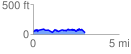
 3.181095 mi
 362.57 ft
 371.46 ft
 -8.89 ft
 2.21 %
GPX Downloads: Track Route
![]()
|
| at: |
Francis Marion National Forest |
show on map
animate
3.181095 mi
362.57 ft
371.46 ft
-8.89 ft
2.21 %