|
| at: |
Francis Marion National Forest |
Data from USFS GIS
 show on map
 animate
Trail users:


Elevation Profile
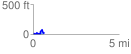
 0.624532 mi
 155.83 ft
 134.34 ft
 21.48 ft
 4.73 %
GPX Downloads: Track Route
![]()
|
| at: |
Francis Marion National Forest |
show on map
animate
0.624532 mi
155.83 ft
134.34 ft
21.48 ft
4.73 %