|
| at: |
Francis Marion National Forest |
Data from USFS GIS
 show on map
 animate
Trail users:


Elevation Profile
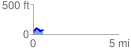
 0.567630 mi
 108.62 ft
 67.07 ft
 41.55 ft
 3.62 %
GPX Downloads: Track Route
![]()
|
| at: |
Francis Marion National Forest |
show on map
animate
0.567630 mi
108.62 ft
67.07 ft
41.55 ft
3.62 %