|
| at: |
Francis Marion National Forest |
Data from USFS GIS
 show on map
 animate
Trail users:


Elevation Profile
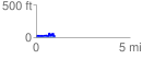
 1.040884 mi
 140.95 ft
 149.28 ft
 -8.33 ft
 2.72 %
GPX Downloads: Track Route
![]()
|
| at: |
Francis Marion National Forest |
show on map
animate
1.040884 mi
140.95 ft
149.28 ft
-8.33 ft
2.72 %