|
| at: |
Francis Marion National Forest |
Data from USFS GIS
 show on map
 animate
Trail users:


Elevation Profile
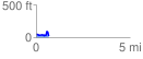
 0.674587 mi
 73.47 ft
 106.35 ft
 -32.88 ft
 2.99 %
GPX Downloads: Track Route
![]()
|
| at: |
Francis Marion National Forest |
show on map
animate
0.674587 mi
73.47 ft
106.35 ft
-32.88 ft
2.99 %