|
| at: |
Francis Marion National Forest |
Data from USFS GIS
 show on map
 animate
Trail users:


Elevation Profile
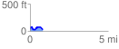
 0.813017 mi
 118.89 ft
 121.79 ft
 -2.89 ft
 2.84 %
GPX Downloads: Track Route
![]()
|
| at: |
Francis Marion National Forest |
show on map
animate
0.813017 mi
118.89 ft
121.79 ft
-2.89 ft
2.84 %