|
| at: |
Francis Marion National Forest |
Data from USFS GIS
 show on map
 animate
Trail users:


Elevation Profile
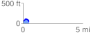
 0.501577 mi
 79.56 ft
 92.90 ft
 -13.35 ft
 3.51 %
GPX Downloads: Track Route
![]()
|
| at: |
Francis Marion National Forest |
show on map
animate
0.501577 mi
79.56 ft
92.90 ft
-13.35 ft
3.51 %